Welcome to the Old Sexton’s House Museum
The exhibition is divided into fifteen stations and begins on the left with the Iron Age in Hesse.
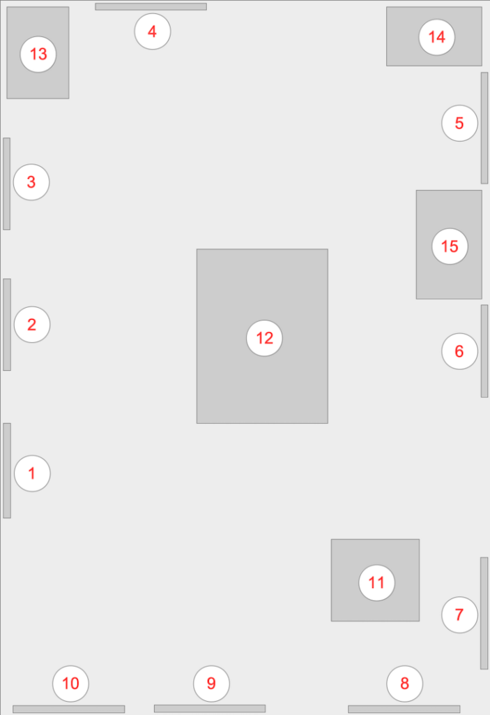
Text panels and display case in the floor
- 1 – Iron Age in Hesse
- 1-1 The Settlement of the Central Uplands
- 2 – The Surrounding Area
- 3 – Settlement and Fortification
- 4 – The Celts on the Christenberg
- 4-1 – Iron Age People
- 5 – The Saxon Wars
- Reconstruction of the Castle in the 10th Century
- 6 – The Construction of Kesterburg Castle
- 6-1 Technology and Materials of a Major Construction Site
- 7 – The Franks on the Christenberg
- 7-1 Northern Hesse in the Early Middle Ages
- 7-2 Frankish History up to the Beginning of the 8th Century
- 8 – St. Martin’s Church
- 8-1 The Deanery of Kesterburg
- 9 – Missionary Work
- 10 – Stages of Architectural History
- 11 – The display case in the floor
Other exhibits
- 12 – Display case in the middle
- 13 – Model of a fortification wall
- 14 – House model
- 15 – Display case
- 15 – Model of a gate system
Besides nearly eighty fortified hilltop settlements, such as ringforts and castles of varying sizes and dates, hundreds of Iron Age sites have been discovered in Hesse. However, little evidence of the splendor of the princely tombs at the princely seats of southern Germany and the lucrative trade relations with the ancient world of the Mediterranean is found north of the Glauberg.
The fundamental developmental trends of the South German Iron Age from the eighth to seventh centuries BC can certainly be observed in northern Hesse and the other regions of the Central Uplands. This applies, for example, to fortifications, settlements, burial customs, special techniques, and fashion. Traces of settlements away from the fortified hilltop settlements are numerous and can be identified by clusters of finds at individual sites and by excavation finds, such as pits and postholes – from house construction – with corresponding artifacts. Comprehensive finds are very rare, at least in northern Hesse.
The increased settlement of the southern Central Uplands regions is partly linked to the search for raw materials – especially iron ore. Among the known Iron Age fortifications in Hesse, besides Christenberg and Glauberg, are several sites that developed into town-like settlements – so-called oppida – of sometimes impressive size during the last two centuries BC. Characteristic of their classification as oppida, besides size and dating, are, among other things, the finds of Celtic gold coins.
The Altenburg near Niedenstein, with its fifteen-hectare plateau, expanded to sixty hectares after several walled additions. The fortification on the Dünsberg – near Biebertal-Fellinghausen, northwest of Giessen – was probably built around 500 BC. The continuity of settlement leading to the oppidum, which at its greatest extent covered ninety hectares, has not yet been definitively established. After 50 BC, the Dünsberg was conquered by Germanic tribes and probably destroyed by the Romans shortly before the turn of the millennium.
The Heidetränk oppidum – today Oberursel-Oberstedten, northwest of Frankfurt on the eastern edge of the Taunus Mountains – was built around 300 BC as a fortification around two older ring walls. With a total area of 130 hectares, it was the largest oppidum in Hesse. Among the smaller oppida in Hesse is the Amöneburg, located in close proximity to the Christenberg.
The second half of the first century BC marks a turning point in the Late Iron Age Celtic settlement of Hesse. Germanic tribes displaced the Celts from their settlement areas. Archaeological findings at the Dünsberg impressively demonstrate this.
During their campaigns northward across the Rhine-Main region, the Romans became embroiled in armed conflicts with Germanic tribes around the turn of the millennium.
Iron Age finds have also been discovered in the area surrounding Christenberg, in the southwestern Burgwald forest. In the immediate vicinity, ceramics and traces of settlements have been found at Klutzkopf to the northwest, near the medieval deserted village of Thalhausen to the north, and east of Christenberg at Lichten Heide.
During the archaeological excavations on Christenberg, numerous finds, particularly ceramics, were recovered. In addition, there were finds made of metal – bronze and iron – and organic materials – such as bones. All of the finds originate from the settlement area of the mountain plateau.
The ceramic finds from Christenberg can be categorized into various vessel types – pots, bowls, and dishes.
Based on the decorations on the objects, many belong to the Hessian-Thuringian line decoration group. The everyday tableware was decorated with lines and strokes in geometric patterns. Often, diamonds or triangles are depicted. The stamped vessels of the Braubach and Amöneburg types are of a different type.
At this time, the first examples of pottery made on a potter’s wheel also appear on the site. Alongside everyday tableware, spinning wheels, also made of ceramic, indicate a peaceful settlement. With their varying sizes and materials, these were used for spinning wool and other materials into thread. As spinning wheels, they set the material being spun into rotation, thus producing a strong thread.
The bronze finds, with the exception of a few fibulae, survive only as fragments. These include simple wire rings, knotted rings, and various fibulae.
The majority of the iron finds are tools used in daily life. These include socketed chisels, knives, chisels, and fittings. Apart from a spearhead and some unidentified arrowheads, no weapons were found on the Christenberg.
The settlement of Christenberg – its predecessor settlement on the Lützelburg – and its surrounding area began, among other reasons, due to the iron ore deposits in the immediate vicinity. Christenberg was fortified around 420 BC. The Lützelburg, also fortified but considerably smaller at 1.5 hectares, had become too small for the growing population.
To fortify the plateau, a timber-stone-earth wall approximately 800 meters long was constructed around the entire area. The wall’s interior was built of timbers stacked in a box-like fashion. Several boxes filled with earth and stones stood close together, and the dry-stone masonry facing them on both the inside and outside formed a defensive structure. A wooden parapet or walkway served as the upper termination. The only access to the plateau – a gate – was located in the southeastern section of the wall. Reconstructing this gate complex is difficult, as only the collapsed stones and postholes of the structure remain. The presence of inhabitants within the gate is even harder to ascertain than the fortifications themselves. However, the sheer number of finds suggests a dense settlement.
From the heights west of the Wetschaft Valley, the Christenberg – medievally known as Kesterburg – near Münchhausen is visible from afar. The large, treeless plateau, at an altitude of 387 meters, drops steeply on three sides. Only to the east does it slope more gently into the Burgwald forest.
For a long time, it was believed that the first permanent settlement and fortification of the mountain occurred in the early Middle Ages, during the era of the wars between the Franks and Saxons. However, the mountain had already been settled a thousand years earlier – in the early fifth century BC – for a period of about two hundred years. Furthermore, just a few hundred meters northwest of the Christenberg, the Lützelburg – an older and smaller settlement – existed as its immediate predecessor. The Iron Age settlement on the Christenberg ended around 200 BC for unknown reasons. The entire fortification burned down. The inhabitants sought a new settlement site, perhaps on the Eisenberg near Battenberg, only a few kilometers away. It was only nine hundred years later that this strategically and powerfully advantageous location was used again by people under different historical circumstances.
The settlement of Lützelburg and Christenberg dates back to the so-called Iron Age, which in Central Europe lasted from approximately 800 BC to the beginning of the Common Era.
Like the Stone and Bronze Ages, the Iron Age is named by archaeologists after a new, predominant material, particularly for weapons and tools. The people of this time—referred to here as Celts—left no written records of their own. No accounts of individuals or events exist. The origins of the Celts remain shrouded in mystery.
Nevertheless, the settlement on the Christenberg is a prominent Celtic settlement site. Along with the Glauberg, it holds particular significance for archaeological research in Hesse.
Kesterburg Castle was a border fortification during times of war. It was manned by soldiers who secured the sphere of influence of the Frankish royal power. Military action near Kesterburg Castle is only recorded once in written sources, in a chronicle.
In the Battle of Laisa and Battenfeld on the upper Eder River in 778, the Frankish troops stationed at Kesterburg Castle fought against Saxon forces. Between 772 and 795, the Frankish troops were led through northern Hesse into Saxon territory in several campaigns. Kesterburg Castle was an important staging post on this route.
Amöneburg Castle lay one stage away to the southeast, and Büraburg Castle to the northeast.
After the end of the Saxon Wars in the ninth century, Kesterburg Castle lost its military significance. The fortifications were no longer maintained, and Kesterburg fell into ruin.
The defensive tower-like outworks of the south gate, the north gate, the northwest tower, and the semicircular tower attached to the northeast corner of the curtain wall date from the period after 900. Large sections of the curtain wall from the Carolingian construction phase, which had collapsed, were rebuilt. The reason for this renewed expansion of Kesterburg Castle was the struggle between two high-ranking noble families for the inheritance of the Carolingian kingship in the East Frankish realm.
The Frankish Conradines had established a powerful territory in the Hessian region, starting from the lower Lahn Valley. During this time, they competed with the Saxon Liudolfings, from whose ranks emerged a significant king, Henry I, who reigned from 918 to 936.
The commanding position on the western edge of the Burgwald forest was the deciding factor in choosing the site. The fortification on the plateau afforded a panoramic view across the Wetschaft Valley to the so-called Wine Road or Wagon Road. For the Carolingians, the Wine Road was the most important route for troop deployment from the Rhine-Main region to Westphalia during their campaigns against the Saxons in the eighth century. Numerous smaller castles from the Carolingian era were located along this road.
Nobles from the regional ruling class were commissioned to explore the terrain and construct the castle. Master builders, craftsmen, and numerous laborers had to be employed for the actual planning and execution of the construction work. Most of the workforce was likely recruited from the immediate surrounding area. First, the primeval forest, which had grown over centuries, had to be cleared. The plateau and the flat terrain to the east each covered four hectares. Additionally, the steep slopes to the north, west, and south were probably leveled to give the lords of the castle an unobstructed view of the surrounding countryside. In total, timber from fifteen to twenty hectares of forest was harvested, which could be used immediately as construction timber and firewood.
From the start of construction, Kesterburg Castle was a major construction site with hundreds of workers. Twenty-four thousand tons of rubble and mortar were needed for the ring wall – approximately six meters high, two meters wide, and eight hundred meters long. The variegated sandstone used came from nearby quarries. Lime, sand, and water for preparing the mortar were presumably transported up the mountain by one- or two-axle ox-drawn carts.
The builders constructed the ring wall using a shell-like method. They filled the space between the shells with stone and mortar. In the first phase of construction, an area of three hectares was fortified. A wide strip – on the flat eastern side – lay outside the fortifications. This area must have been incorporated into the fortress by extending the wall after only a short time. The castle, as constructed in this first phase, had a chamber gate in the south and a smaller gate between widened sections of the wall in the north.
The flat terrain on the eastern side, the point of attack, was secured by a system of ramparts and ditches. Two deep V-shaped ditches adjoined the wall. Up to seven ditches and ramparts followed an unfortified outer bailey.
The buildings within the castle walls were constructed of wood. There were dwellings, storage sheds, a forge, and very likely also a chapel. Simple barracks served as quarters for the soldiers.
In the first half of the eighth century, Christian Franks built a fortification on the four-hectare site of the mountain plateau. Its location was strategically advantageous, only a day’s ride or two from the settlement area of the pagan Saxons. Military bases sprang up frequently in the Frankish-Saxon border region because the struggles for supremacy in northwestern Germany flared up repeatedly during this period.
Commanders of such fortifications were mostly Frankish nobles. It is likely that they also had a chapel or private church built on the Kesterburg at an early date. The predecessors of the present church therefore date back a long way.
In the late eighth century, the conflicts culminated in the Saxon Wars of the Frankish king Charlemagne, who lived from 748 to 814.
For a period of about one hundred years, the fortress on the Christenberg played a significant role in these wars.
Kesterburg Castle lies in the heart of northern Hesse. Frankish chroniclers, however, do not mention this area in their writings about the conquests of the sixth century. Southern Hesse—roughly as far as Giessen—and the lower Lahn Valley—as far as the Weilburg-Wetzlar area—had already come under Frankish rule at an early stage.
The Katten tribe settled in Old Hesse. This encompassed the historical districts of Oberlahngau and Hessengau, as well as territories north of the former Roman Limes border.
Since written sources do not report on conquests of the Hessian tribal territories, it is generally assumed that the Franks gradually and peacefully integrated northern Hesse into the Frankish Empire from the sixth century onward.
At the end of the seventh century, the Saxons conquered the territories of the Frankish Bructeri—Borthari—north of the Diemel River and threatened the small tribes of northern Hesse. During this period, the Carolingian mayor of the palace, Pippin the Middle (687–714), had secured his rule, particularly in the eastern part of the Frankish kingdom, and was able to respond effectively to Saxon incursions.
Among the most urgent measures was the establishment of large military strongholds. In northern Hesse, Büraburg near Fritzlar, as well as probably Amöneburg and Kesterburg on the Christenberg, were built.
Originally, the Franks and Saxons were allied Germanic tribes. The first written records, dating from late Roman times, mention several Germanic tribes on the right bank of the Lower Rhine and refer to them collectively as Franks.
From the mid-fourth century onward, Saxons advancing southwest from northern Germany pushed the Saale Franks into the Rhine estuary. By the mid-fifth century, the Rhine Franks had occupied extensive territories on both sides of the Lower Rhine and established an independent realm.
At this time, there was no unified Frankish tribe. Numerous smaller tribal groups often operated independently of one another. The Franks were granted high military posts in Gaul under Roman rule and later built their own powerful armies.
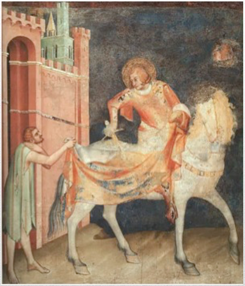
The Christenberg Church, as St. Martin’s Church, bears the name of a saint venerated as early as the Early Middle Ages – Bishop Martin of Tours. As a Roman soldier, Martin shared his cloak with a beggar. Later, he embarked on a religious career and was elected bishop. This combination of military background and Christian action may have been what elevated Martin to the status of national saint of the Frankish Empire. Churches founded during the Frankish expansion from the eighth century onward often bear the name of this saint.
The church on Christenberg Hill had been an administrative center of considerable size since the Middle Ages. The parish priest, then a Catholic, also lived there with his staff.
The Deanery of Kesterburg, an administrative unit encompassing numerous parishes, included the towns of Battenfeld, Bentreff, Breidenbach, Bromskirchen, Dautphe, Frankenau, Geismar, Gemünden, Grüsen, Kesterburg, Michelbach, Röddenau, Schönstadt, Vöhl, and Wetter. The deanery was subordinate to the Archdeaconry of St. Stephen in Mainz, which in turn belonged to the Archdiocese of Mainz.
St. Martin’s Church on Christenberg Hill was the parish church of Münchhausen until the Reformation, even after the pastor had moved his residence to Münchhausen around 1503. Johann Althaus, pastor in Münchhausen from 1504 to 1526, was also the first Protestant clergyman of the parish after the Reformation.
The church in Münchhausen, dedicated to St. Mary in Catholic times, became the new parish church. St. Martin’s Church continues to serve as the mortuary chapel for the surrounding cemetery. On certain major feast days, services for the entire parish are still held on Christenberg. For over three hundred years, the parish included the villages of Münchhausen, Wollmar, Roda, Ernsthausen, Obersimtshausen, Mittelsimtshausen, and Schlagpfütze. The later parish of Christenberg consisted of the villages of Münchhausen and Wollmar. The present-day parish of Christenberg-Hollende comprises the villages of Münchhausen, Wollmar, Simtshausen, Niederasphe, and Treisbach.
Christianity Comes to the Mountain
It is not definitively known who brought Christianity to our region. At the time of Boniface’s missionary work, during which he founded numerous churches and monasteries in what is now Hesse, a Frankish fortification existed on the mountain to secure the border against the Saxons. We no longer know its name. It was only in 1227 that it was referred to as „Kesterburg.“ It is highly likely that the castle’s commanders were Frankish nobles who already came from a Christian background. Besides „Kesterburg,“ the Frankish royal power had also built Büraburg near Fritzlar and Amöneburg to secure its dominion against the pagan Saxons who were pushing south from the Diemel River.
Between 721 and 733, Boniface founded churches and monasteries in Amöneburg and Fritzlar as part of his missionary work. In 723, he had the so-called Donar Oak felled near Geißmar and the wood used to build the first church in Fritzlar.
There are no written records of Boniface visiting Christenberg. At best, one could assume that Boniface visited all the Frankish castles in the border region with Saxony on his journey through northern Hesse. However, unlike Büraburg-Fritzlar and Amöneburg, the „Kesterburg“ on Christenberg is not mentioned by his biographer, Willibald.
The „Boniface Steps“ are a stone near the old entrance to Kesterburg that may have preserved ancient knowledge. According to legend, they represent a footprint and walking stick imprint of Boniface.
It is possible that a first church existed on the Christenberg as early as 720 – unlike in Fritzlar and Amöneburg. The building was very likely constructed entirely of wood, as no stone foundations from that period have been found.
However, during renovations inside St. Martin’s Church in 1953, the foundations of older church buildings were discovered beneath the floor. The oldest structure, probably from the Carolingian period, was even wider than the current nave and had a rectangular chancel. Whether a tower stood at the west end of the building could not be definitively proven. The angled walls perhaps indicate a twin-towered westwork.
In the 11th century, a new church was built with a west tower and a semicircular eastern chancel apse. The apse was demolished in 1520 and replaced by a large Gothic chancel. The exterior pulpit and the buttresses of the nave date from the late Middle Ages or the early modern period.
The early medieval finds show building and entrenching tools. Without these—and other—tools, the construction of fortifications like Kesterburg on the Christenberg would not have been possible.
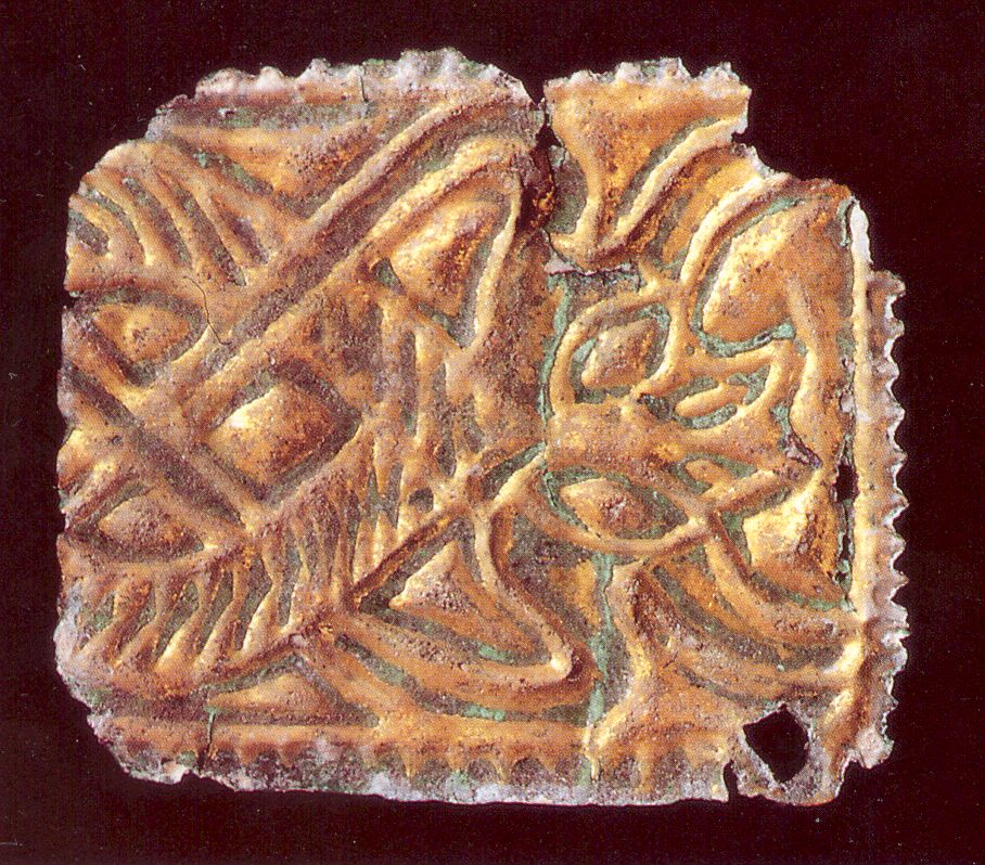
An iron cross-peen is depicted in the upper left.
In the upper right lie iron tools such as scissors, knives, sickles, nails, and a firesteel, some of which come from grave goods.
To the right are weapons and riding equipment made of iron—a gold-inlaid piece of a stirrup and a spur fragment—both replicas—as well as arrowheads.
Below are shards of handmade local pottery. Carolingian wheel-thrown pottery was produced in large potteries based on models from the Rhineland and traded over long distances.